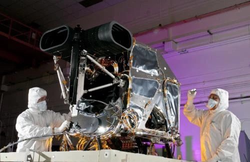
Ball Aerospace & Technologies Corp. has successfully completed pre-ship review for the Operational Land Imager (OLI) to fly aboard the Landsat Data Continuity Mission (LDCM). The imaging instrument is currently being prepared for shipment to Orbital Sciences Corporation, Gilbert, Ariz., where satellite integration will occur prior to a scheduled launch in December 2012.
Landsat satellites capture unique Earth surface data vital to agricultural, water management, disaster response, scientific and national security uses. "OLI provides the key sensor technology to allow continuation of Landsat Earth observations into a fourth decade," says Ball Aerospace president and CEO David L. Taylor. "This continuation is essential to maintain seamless acquisition of moderate resolution imagery of the Earth from space that is not captured by other private or public sources."
A multitude of scientific, commercial and governmental users rely on Landsat for moderate-resolution multispectral Earth observation data. OLI will capture images of nine spectral bands in the visible, near infrared and shortwave infrared, helping scientists understand the impact of land use change. The OLI instrument provides 15-meter (49ft.) panchromatic and 30m multi-spectral Earth-imaging spatial-resolution capability, and includes a 185km swath allowing the entire globe to be imaged every 16 days.
The Landsat program is a series of Earth-observing satellite missions jointly managed by NASA and the U.S. Geological Survey. For nearly 40 years, Landsat satellites have continuously and consistently collected images of Earth, creating an historical archive unmatched in quality, detail, coverage, and length. LDCM will extend Landsat's unparalleled global land surface observation record.
Latest from Aerospace Manufacturing and Design
- Archer to test Starlink onboard its Midnight air taxis
- System eliminates cage-creep in sliding bearings
- Bodo Möller Chemie signs worldwide supply contract with Airbus
- Sandvik Coromant's CoroTurn Plus turning adapter
- ZOLLER Technology Days & Smart Manufacturing Summit May 13-14, 2026 in Ann Arbor, Michigan
- Walter's TC620 Supreme multi-row thread mill family
- ThermOmegaTech achieves CMMC Level 2 C3PAO certification
- One-touch precision flex locators